Stay on track and in touch with the rugged Montana 760i handheld GPS navigator with inReach technology. Built to guide you through all kinds of adventures, it includes TopoActive mapping, a glove-friendly 5¡± color touchscreen and long battery life. When you go beyond the limits of cell service, stay connected with inReach technology for two-way messaging and interactive SOS alerts (active subscription required; some jurisdictions regulate or prohibit the use of satellite communication devices). Plus, the built-in camera lets you capture and tag the location of your photos along the way.
Features
¡¤ Rugged 5¡± handheld GPS navigator with inReach technology helps guide your adventures and keep you connected to loved ones when you go beyond the limits of cell service (active subscription required; some jurisdictions regulate or prohibit the use of satellite communication devices)
¡¤ Venture with peace of mind; an active inReach satellite communication subscription gives you access to two-way text messaging, location tracking via the 100% global Iridium satellite network and interactive SOS to the Garmin ResponseSM team, an international 24/7-staffed emergency
response coordination center (some jurisdictions regulate or prohibit the use of satellite communication devices)
¡¤ Built-in 8-megapixel autofocus camera lets you capture and tag the location of your photos so you can navigate back to those sites later
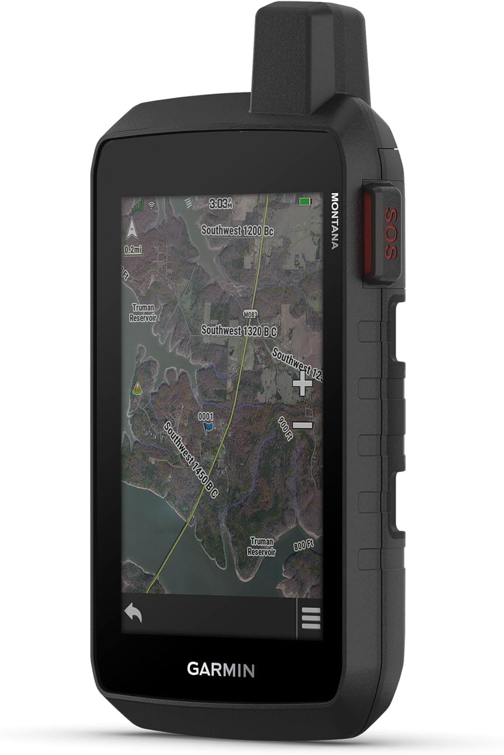
¡¤ 5¡± glove-friendly, easy-to-view color touchscreen; available with versatile mounting options (sold separately), depending on your activity
¡¤ Navigate your adventures with included TopoActive maps, City Navigator maps for on-road and the ability to download additional maps, such as BlueChart g3 charts for water (sold separately)
¡¤ Rugged construction is rated to MIL-STD 810 for thermal, shock and vibration and IPX7 for water-resistance
¡¤ Downloadable high-resolution satellite imagery shows photorealistic overhead views and lets you create waypoints based on landmarks
¡¤ Expanded 32 GB memory capacity lets you store additional maps and more to keep your expeditions on course; with a subscription to Outdoor Maps+ (sold separately), get ongoing access to a wide variety of premium mapping content, which you can download to your navigator via Wi-Fi technology
¡¤ Compatible with the Garmin Explore smartphone app to help you manage waypoints, routes, activities and collections; also, use tracks and review trip data from the field
¡¤ Rechargeable lithium-ion battery pack can provide up to 24 hours of battery life in GPS mode and up to 432 hours in expedition mode between charges
¡¤ Recharge easily with a standard USB-C cable
¡¤ Built-in ABC sensors help you navigate your next trail, including an altimeter for elevation data, barometer to monitor weather and 3-axis electronic compass
¡¤ Access up-to-date active weather forecasts via the Garmin Connect app on your compatible smartphone
¡¤ With an active inReach satellite communication subscription, the inReach weather forecast service provides detailed updates directly to your Montana handheld or paired devices, so you¡¯ll know what to expect en route
¡¤ Using your live tracking page, followers can see your progress, ping your device to see your GPS location and exchange messages during your trip (requires active inReach satellite communication subscription)
¡¤ Multi-GNSS satellite network (GPS and Galileo) support for exploration in more challenging environments
Ca Residents:Click herefor Proposition 65 warning